We were commissioned, through Spectrum Ecology, to assess an open-area site, which had outline planning permission for an industrial installation, for ecological issues (EcIA) that might affect the preparation of a change of use planning permission, for inclusion in the Local Development Plan. We had already conducted a Phase 1 Habitat survey and analysed the Local Ecological Records for the site, near Tonyrefail, south Wales, under a previous commission.
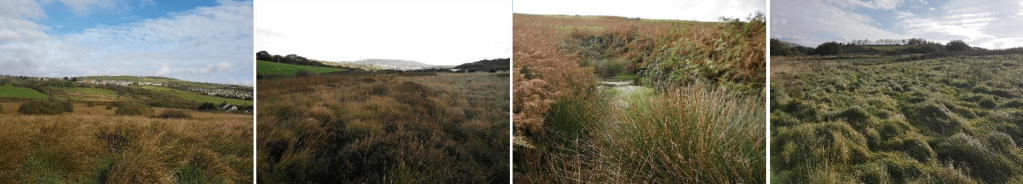
The site was approximately 20 acres of land that has historically been used for livestock grazing, but had returned to a more naturalised state through lack of management. It was surrounded by intensively managed habitats, with industrial and domestic developments to the east and livestock grazing land around all of the other boundaries, with the exception of a small area of regenerating woodland/scrub linking to the north-eastern corner. The area was gently sloping with a northerly aspect, with several drainage ditches and a man-made structure to the south of a small pond situated in the north west of the site, and the sward was predominantly ‘ffridd’ mosaic habitat (i.e. a mosaic of acid/marshy grassland and associated habitats).
The local records check included historic maps of the area, labelling the site predominantly as wet heath with patches of poor grassland and spots of marshy grassland. The records also showed that part of the site had supported remnants of peat bog. However, our surveys revealed that molinia-dominated marshy grassland was now widespread, accompanied by other grassland and areas of bracken and a small pond, leaving very little wet heath in place. No evidence of peat was discovered during our surveys, but the likely area had been modified in the distant past to build a now-disused railway, and the remnants of the bog had probably been overgrown, so more detailed studies would be required in order to consider protection and regeneration of this ecologically important habitat.
The densely-packed molinia grasslands were assessed as currently being unable to support the food-plants of the protected Marsh Fritillary butterfly, but a detailed NVC survey during the late spring/early summer would confirm whether suitable species were present and thus merit protection. The pond and wet dwarf heath were assessed as being protected habitats requiring boundary zones between them and any development. The areas of grassland and bracken were, however, unlikely to restrict development, provided they included no protected species populations. Maps were prepared to indicate the habitat areas of high, medium and low conservation value to illustrate the potential limitations to development. Maps were also prepared to define areas which might be suitable to reptile, amphibian, harvest mouse, water vole, ground-nesting bird habitats, as well as native bluebell, and recommendations made for follow-up species-specific surveys.
Although there were 3 protected sites within 15km of the study area, it was assessed that the most likely project would have a small zone of influence and there was a low likelihood of their being affected by development on this area. However, the area was included within boundaries of a SINC and it was advised that development of the site would undoubtedly disrupt connectivity between eastern and western extents of the SINC.
Project development has been delayed by the need to investigate the presence and significance of peat deposits and the consideration of options.
Visit the “Our Work” page to see other case studies and examples of our work. If you think we could help you with your ecological requirements, please contact us.
